
The Audubon Bird Migration Explorer
Written by Andy McCormick
This is the second of a two-part series on tracking migrating birds. The first column presented information about BirdCast which follows birds in migration using next generation radar (NEXRAD). This column focuses on a finer grained way to follow the migrations of individual bird species using Audubon’s Migration Explorer.

Andy McCormick, Volunteer and Former Board President of Eastside Audubon
Migrating birds have made amazing journeys of thousands of miles from the tropics to seek suitable breeding areas in the northern boreal forest and tundra in North America, Europe, and Asia. Most of this migration occurs at night when most humans are sleeping, but researchers in recent years have developed techniques to track birds during their spring and fall migrations.
BirdCast, a collaboration of the Cornell Lab of Ornithology, Colorado State University, and UMass Amherst uses artificial intelligence to learn from big data sets from next generation weather radar (NEXRAD) to track millions of birds as they make flights overnight. The radar data is then displayed in real time maps of migrating showing the birds as a mass moving over land. However, these radar maps are not able to determine which bird species are migrating or have the ability to follow a single bird.
National Audubon took on the challenge to track birds and developed the Bird Migration Explorer with the help of many partner organizations. Among them are Birds Canada, BirdLife International, the Cornell Lab of Ornithology, and ESRI, a mapping software company. The development team combined tracking data and results from hundreds of bird banding studies with the abundance data of eBird to create interactive maps of birds in migration.
BLACK-HEADED GROSBEAK MIGRATION
The mapping of the Black-headed Grosbeak provides a good example of how the Migration Explorer works. The grosbeak is one of 458 bird species which have maps in the program and it is one of those marked as “tracked” which means tracking data for individual Black-headed Grosbeaks is included in the map.
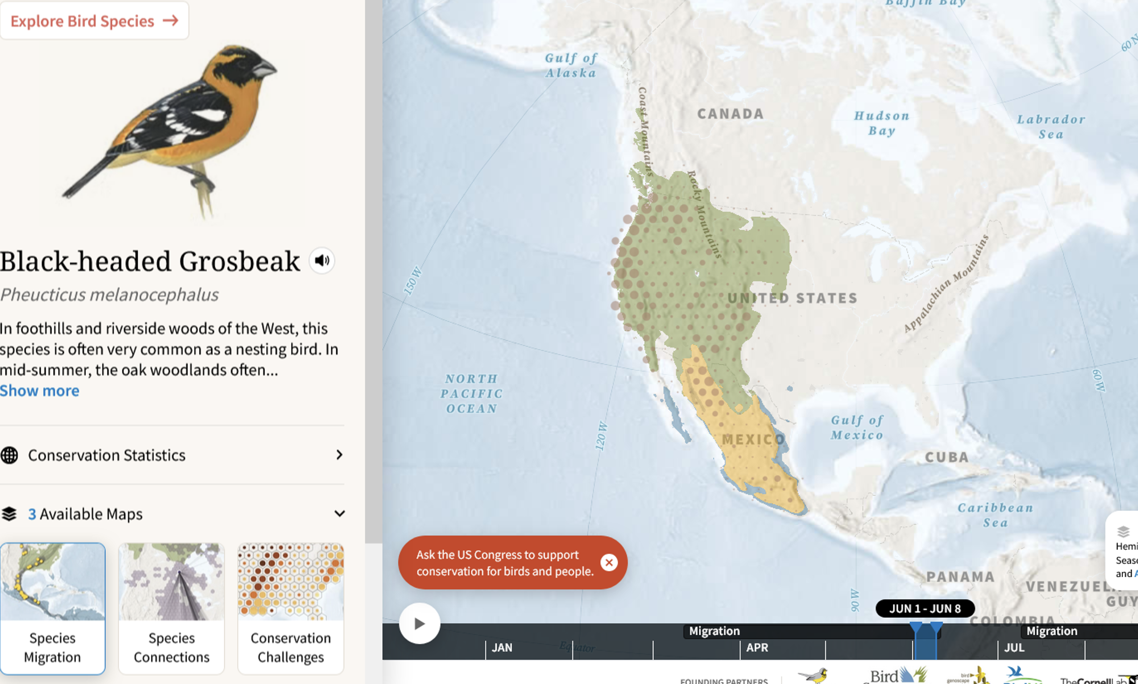
Black-headed Grosbeaks make an early spring migration which you can follow at the Migration Explorer. Once you open the link, the map displays the breeding and wintering areas of the bird’s year in western Canada, the United States, and northern Mexico. Larger-sized dots show greater abundance of grosbeaks and smaller dots show less abundance. The yellow dots indicate the locations of individually tracked birds which can be seen showing where the bird moved on the Black-headed Grosbeak map.
A bar across the bottom of the screen moves through the months and the dots move northward on the map in spring as the grosbeaks populate their breeding habitat in California during the second week of April and in Colorado, Oregon, Washington, and British Columbia by May 10. As the bar moves across the screen the southward movement of the birds become evident around the first of August and the dots on the map move toward Mexico, the grosbeaks primary wintering area.
ADVANCE DATA TRACKING MAKES THE EXPLORER WORK
Two types of tracking data help researchers follow birds in migration. Recent studies have included the fitting of ultra-light-weight GPS (Global Positioning System) tracking devices to the backs of some birds. Each device sends data to the researcher or if the bird can be recaptured the data can be extracted from the device memory.
Radio telemetry is another method for monitoring the locations of birds. Using a similar method during banding, a radio signaling device is attached to the bird. When the bird flies past the antenna of one of more than 2,000 Motus Wildlife Towers, the unique signal from the device on the bird is picked up and registered at the Motus location. The data is then sent to Birds Canada which makes it available to researchers and the public.
Audubon combines these data from hundreds of bird banding and tracking studies with abundance data from eBird to develop interactive maps in the Bird Migration Explorer.
LEARNING TO USE THE MIGRATION EXPLORER
Using the program takes a little practice and Audubon provides two video programs to get you started. The Introductory Video provides a 3-minute overview of the way the explorer works and describes several of its features. The Instruction Guide offers a 7-minute video to get you using the program. Once you have explored one or two birds the process is easy.
The Migration Explorer lets you move from the Migration Map to the Species Connection Map where you can see where the birds go and how they connect their breeding location in the north to wintering locations in the south. As a result of its migration, a Black-headed Grosbeak connects the Pacific Northwest to Central Mexico. Connections like these are valuable aids for conservation work which can be coordinated in both the breeding and wintering areas of migrating birds. Audubon will continue to enrich the program as more researchers provide results of future studies.
Read the first article in this series on BirdCast
Photo Credit: Mick Thompson